Site maps
Mark the work on a map of the yard
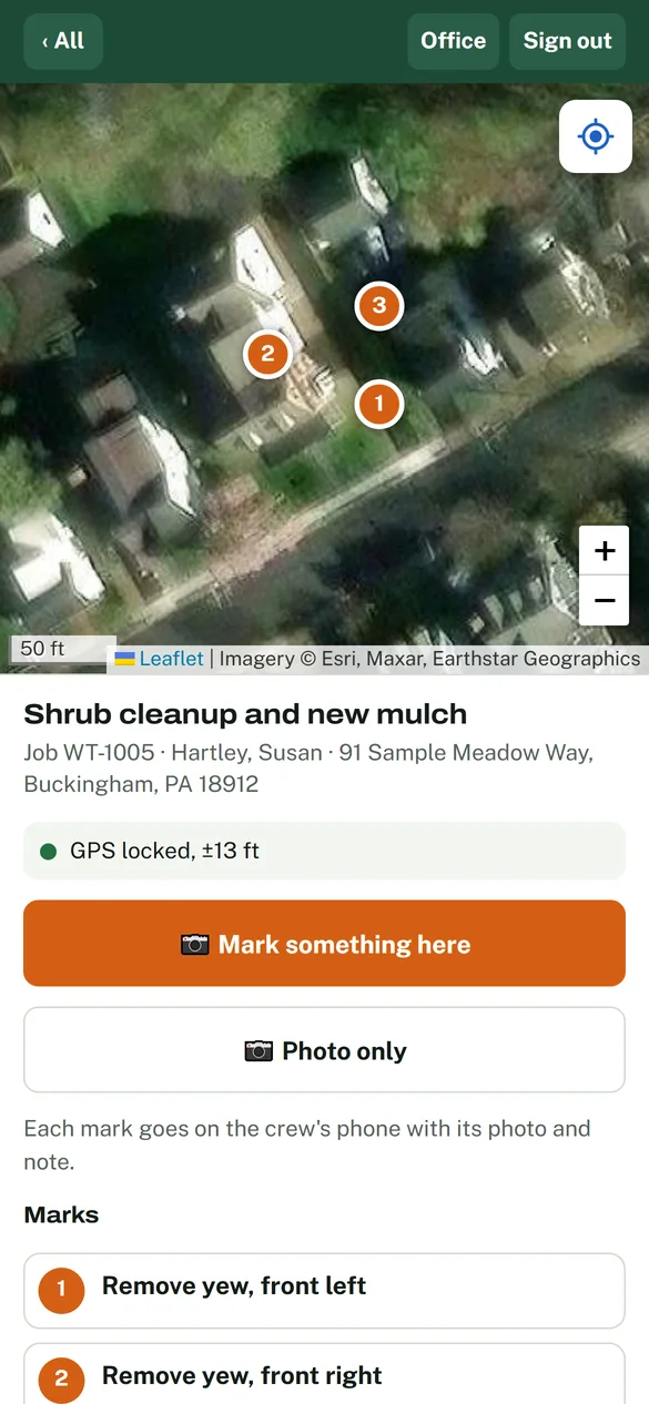
Walk the property with your phone. Photograph each plant, bed or area that needs work, and pin it on an aerial photo with what to do. The customer approves that exact map, and the crew's phones walk them to every mark.
Approved by the customer
- Seven actions Remove, prune, transplant, plant, treat, mulch, repair
- Your photo on every mark
- No app for the customer, and no login
- No signal? Marks save and send later
Why a marked map
“Remove the shrubs in the front bed.” Which ones?
A written work order leaves the crew guessing. They call the office, the office calls the customer, and the truck sits. Or they guess, and a shrub the customer wanted to keep comes out. You can't put that one back.
In Level Yard every piece of work is a numbered mark on an aerial photo of the property, with your photo of the plant and a note. The office, the customer and the crew all look at the same marked map, so there's nothing left to interpret.
Prune the one by the steps.
New mulch.Which shrubs?
How it works
From the walk to the last mark checked off.
-
1 You walk it and mark it
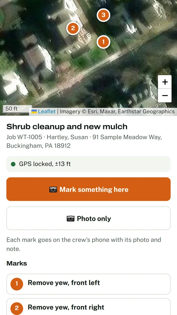
Stand by the shrub, take its photo, and pick what happens to it: remove, prune, transplant, plant, treat, mulch or repair. Add what it is and a note. The mark drops where you're standing, or tap the map to put it exactly where it goes.
Photos that aren't marks can be kept too, for the office and the estimate.
-
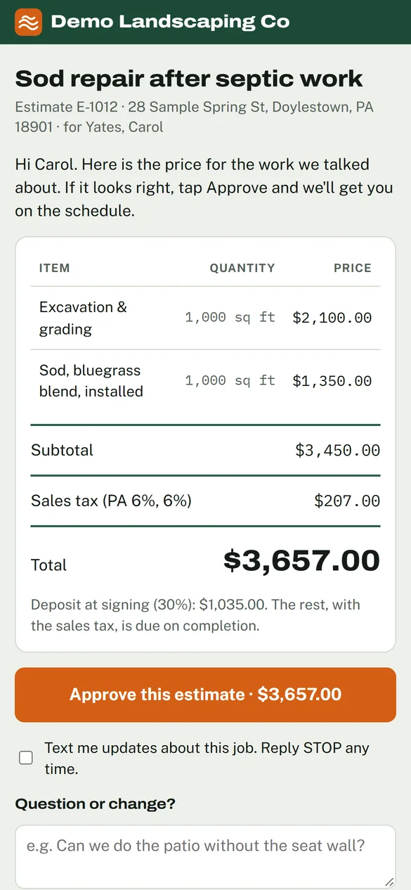
2 It rides along on the estimate
Walk before you quote, and the marks and photos stay with the estimate. You choose which photos the customer sees. When the estimate is won, its marks become the job's plan, already approved.
-
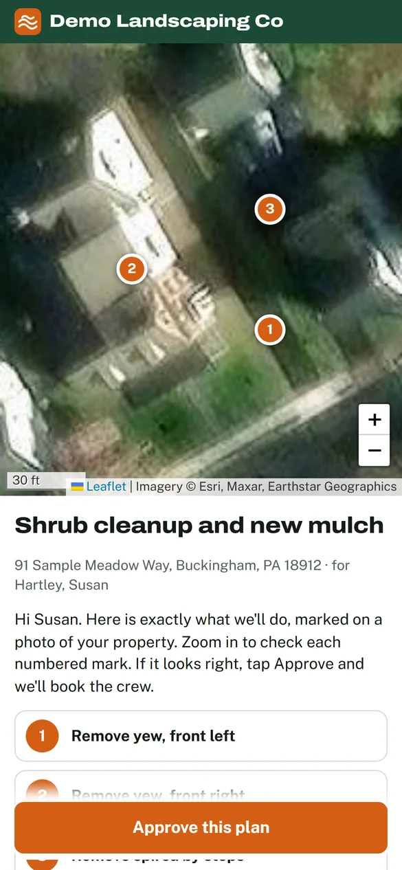
3 The customer approves the map
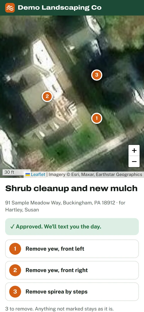
They get a link to that exact map on their phone, zoom in on each numbered mark, and tap Approve. No app and no login. Anything not marked stays as it is, and the approval is saved with the date and time.
The same page later shows when the crew is there, how many marks are done, and the photos once it's finished.
-
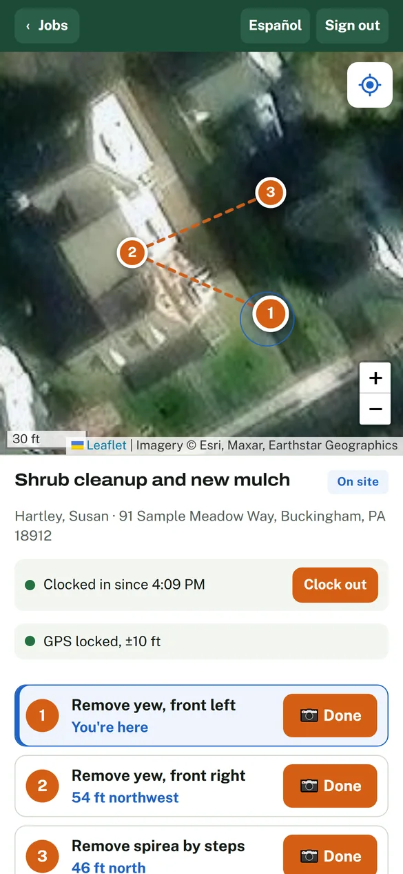
4 The crew works mark to mark
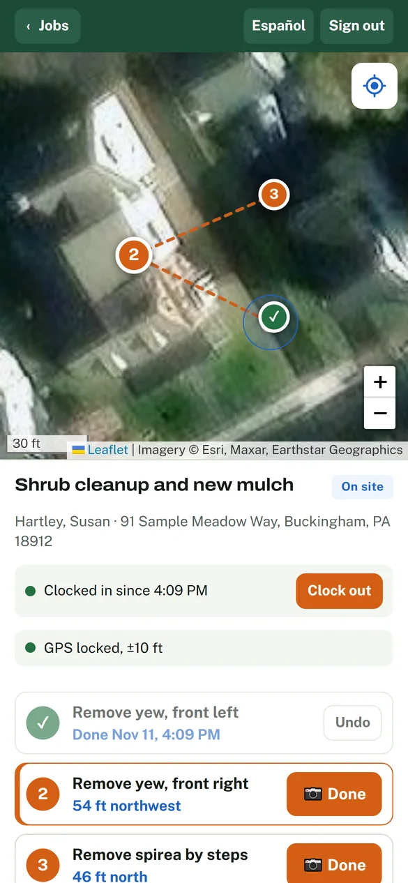
Each mark shows your photo and note, how many feet away it is and in which direction. When they're standing on it, the phone says so. They check each one off, and can snap an after photo.
Spot more work while they're there? A photo and a line, and it lands in the office as a new lead. The crew's screens also come in Spanish, and each person picks their language once.
What to mark
Any job where “which one?” costs you a trip.
Shrub and tree removal
Mark exactly which ones go. Everything else stays.
Planting
Pin where each new plant goes and say what it is.
Pruning
One mark per plant, with how far to take it back in the note.
Bed cleanups and mulch
Mark each bed so none gets skipped on a big property.
Transplants
Mark the plant, and say in the note where it's going.
Repairs and treatments
Edging, a wall cap, a sick tree: show the crew the spot.
Good to know
What the map can and can't do.
GPS gets them close. Your photo gets them exact.
Phone GPS is good to about ten feet. The numbered mark and your photo of the plant settle which one it is.
Aerial photos aren't from this morning
They can be a few years old, and trees can hide a bed. Your photo on each mark shows how it looks today.
No signal at the back of the lot
Marks made on a walk and marks the crew checks off are saved on the phone and sent when the signal comes back.
Questions
What owners ask about site maps.
Does the customer need an app or an account?
No. They get a link that opens the marked map in their phone's browser, and they tap Approve.
Where does the aerial photo come from?
Level Yard uses aerial imagery from Esri, the same kind of photo you see in online maps. You don't need a drone or a drawn site plan.
How close does GPS get the crew?
Phone GPS is usually good to about ten feet. The phone says “You're here” when they're a few steps from the next mark, and your photo of the plant settles which one it is.
What if the customer wants a change?
Edit the marks and the approval resets, so the customer approves the new version.
Do we have to walk every property?
No. You can place marks from the office by tapping the aerial photo. Walking it adds your own photo to each mark, which is what crews find most useful.
Can the crew use it in Spanish?
Yes. Each person picks English or Spanish on their phone, and your office can type notes in Spanish too.
Does it work with no signal?
Yes. Marks made on a walk and marks checked off by the crew are saved on the phone and sent when the signal comes back.
Early access
Mark your next job on a map.
We're setting up a limited number of Pennsylvania landscaping companies before the season starts. Try it on a real property and a real crew.
- Free during early access
- Set up with your own customers and prices
- Your books stay in QuickBooks